


As Earth Day just passed on April 22, the annual celebration of appreciation for the environment, it’s never too late to go out and explore nature. The date may be annual, but Stevenson students can still do their best to experience the beauty our planet has to offer 365 days a year.
The greater Baltimore region has a plethora of scenic landmarks and nature trails. There are three convenient hiking trails within 30 minutes of Owings Mills for the Stevenson community to hike or stroll.
A few trails to enjoy are the Liberty Dam Trail, the Choate Mine Trail, and Prettyboy Reservoir Dam trail. These trails range from easy to moderate, and each trail has signature landmark scenery that make them great places to visit.
Liberty Dam Trail
The Liberty Dam Trail in Marriottsville, Maryland, is about a 20-minute drive from Owings Mills. It is the shortest of the trails listed and has a low level of difficulty. It spans 1.6 miles in length with an elevation gain of 32 feet high. The trail leads you on a scenic hike along the banks of the Liberty Dam. According to some Stevenson students who ventured on the hike, one of the places of note is the waterfall at the end of the trail. Stevenson senior Matthew Cappucci described the trail and waterfall as “a cool place with nice scenery,” and one that he likes to visit often. The trail is great for all skill levels and is primarily used for hiking, walking, and nature trips. Dogs are also welcome on the trail but must be kept on a leash. Check out more about the trail here.
Choate Mine Trail
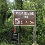
The Choate Mine Trail is located in Soldier’s Delight Natural Environmental Area, Maryland. The trail is about a ten-minute drive from the Stevenson University campus, and one of six trails to explore in the Soldier’s Delight Natural Environmental Area. This is a looping trail with a length of 1.7 miles and an elevation gain of 121 feet. Choate Mine Trail features a variety of historic scenery from abandoned mines to wildlife sanctuaries. The trail is considered moderate difficulty and is described as rocky and muddy in certain sections. Proper preparation for this hike is essential. You can explore and find out more information about the Choate Mine Trail here.
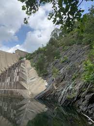
Prettyboy Dam Trail

The Prettyboy Dam Trail, located in Parkton, Maryland, is a trail that runs along the Prettyboy Reservoir. The farthest from Owings Mills of the three trails, Prettyboy Trail is located about 30 minutes from Stevenson’s campus. It is also the longest of the trails reviewed, with a length of 2.6 miles and a 272 feet elevation gain. The trail is considered moderate difficulty, and dogs are welcomed when on a leash. The signature landmarks to see while on this hike is the lake and Dam at the end of the trail. This trail has received rave reviews with hikers of various skill levels describing the trail experience as “a beautiful surprise,” “amazing”, and “wonderful.”
Hiking each of these trails as well as the many others in the Baltimore area are great ways to celebrate Earth throughout the year.
For more information on hiking trails in the area visit Alltrails.com or visitmaryland.org.